Essential Checklist Distance: 4 miles / 7 km / 2 hours Terrain: Fairly flat, minimal road walking, 6 stiles en route, all within the first mile Start: Mill Green Common car park GR638 012 Map: OS Explorer 183 Chelmsford and the Rodings Parking: Mill Green Common car park, just off Ingatestone Road Refreshments: The Cricketers pub is en route and a little further up Ingatestone Road is The Viper pub.
Step 1
Turn right out of the car park at Mill Green Common, past The Cricketers pub and turn left down the footpath by the post box on Hardings Lane. By the large gates on the left, turn left over a stile marked Mill Green Circular Walk. This is also part of the St Peters Way, which is a 45-mile, long-distance route between Chipping Ongar and St Peters on the Wall chapel at Bradwell on Sea. The path runs by a field into a woodland. Climb the next stile and continue ahead. Follow the field edge round to the right. Keep an eye out for a path off to the left in a gap in the hedge. Cross the bridge and stile and walk ahead following the yellow arrow across the pasture. Head for the field gate to the right of the cottage, cross the stile and go straight over the track in to the woods.
The woods and this part of the Common are full of pits and hollows. The ground around here is excellent for making pottery and bricks, and kilns have been found nearby. Potter Row Farm which you just passed, probably derives its name from this industry. The pottery made here, Mill Green Ware, was produced in some quantity in the period c1270-1350, with a thriving export trade to the London markets. During WW1 the area was used as a training ground, the Southern Army Trench Warfare and Bombing School, where numerous soldiers put into practice the techniques they were taught in theory classes in nearby Ingatestone.
Follow the arrows through the woodland out to a lane. Turn right and walk down the footpath signposted as Richards Cottage. Go down the driveway, past the house and over a stile. The path forks, take the left one along the edge of Box Wood. A lot of the trees in Box Wood are hornbeam, recognisable by their smooth bark and known for their hard wood. Cross the next stile and follow the edge of the woods. Cross another stile and do the same. The next stile takes you out into arable fields; take the path ahead towards the telegraph pole. The path gently heads downhill with views across to Ellis and Parkponds Woods, both are Local Wildlife Sites. The path eventually meets a lane.
Step 2
Turn right then left on to the next path opposite the second cottage. Head to the left of the copse and as you go over the rise youll see the entrance in to the next field among the trees. Cross the bridge and follow the path beside the field and then through the crop. At the end of the field, cross the bridge and enter Ellis Wood, looking out for deer.
At the first wide woodland ride, cross straight over on to a well-trodden track. At the edge of the woods, by the fingerposts, turn right and then left on to Cock Lane.
At the road, turn left then right on to Metsons Lane, by the wood yard. Keep walking past the yard and alongside Barrow Wood. After going past Barrow Farm, now a riding school for the disabled, the track turns back in to a lane and meets the road. Go straight across the road on to the footpath opposite.
The footpath comes out on a surfaced track, turn left and head back to the road. Cross the road on to the bridleway opposite and back in to the woods. The track eventually becomes Maple Tree Lane, keep ahead at all junctions. When the road, after km, turns left, go right on to a bridleway back on to Mill Green Common.
Mill Green Common was part of ancient Writtle Forest, a royal forest, which included a Hermitage for a monk who was appointed by the King. The Common was one of the plains on the outside of the forest and is designated as an ancient landscape by Essex County Council. This part of Mill Green is heathland and is a very rare habitat in Essex. There are information boards in the car park which explain the history and ecology of this remarkable area.
Essex County Council has made the Order under section 14(1) of the Road Traffic Regulation Act 1984 to to temporarily close Footpath 25, Ingatestone & Fryerning, from its junction with Hardings Lane south for approximately 260 metres.
The closure will continue until 9 November 2023 or until the works have been completed and is required for the safety of the public and workforce while the replacement of fencing alongside footpath is undertaken.
The alternative route will be via Footpaths 25, 26, 20, 10 and vice versa.
For any info, please contact Essex County Council on 0345 603 7631 or visit their website www.essex.gov.uk/highways
This walk crosses countryside between Ingatestone and Mountnessing. It is described in a clockwise direction beginning at Ingatestone Hall. It may also be joined from footpaths linking into the circuit.
From Ingatestone Hall follow the footpath past the barns. William Petre built this hall after buying the previous manor house in 1539. After passing the Hall there are extensive panoramic views as you head towards Buttsbury Church on the hill in front of you.
At the River Wid turn right. In Old English the Wid was known as Writolaburna, meaning to chirp or chatter – a real babbling brook! As you walk along its banks, keep an eye out for Moorhens darting in and out of the reeds. Follow the path alongside the fields and hedges right down to Mountnessing Hall.
The Church of St Giles takes its name from the patron saint of beggars and cripples and stands next to Mountnessing Hall, which is Elizabethan with a Gerogian façade. See if you can spot the false window.
After passing between the house and barn, turn right for the shorter route or carry on straight across the field for the longer route.
The short route crosses a field and continues on to Padhams Green. After reaching the railway turn right towards Bacons Farm, and then follow the road back to Ingatestone Hall.
The longer route crosses several fields before coming into Mountnessing across the A12. You will pass St John’s, ‘The Iron Church’, which opened in 1873 and was built to be close to the village, and then you will approach a postmill.
A windmill was first recorded in Mountnessing in 1580. The present postmill was used regularly until 1924 when the owner started using an oil engine to grind corn. The walk through the open fields from the windmill over to Trueloves Lane commands superb views.
When you reach Trueloves Lane turn right and then left to go over the A12. Cross the main road to Roman Road and then head left towards Rye Walk. At the end of the road turn left and then right taking the footpath to go under the railway via the pedestrian tunnel. Then absorb the views as you head back toward Ingatestone Hall to finish the walk.
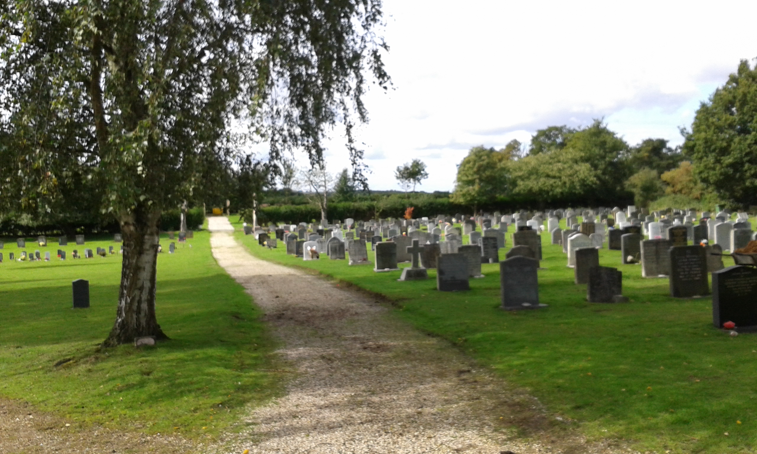
The Parish Council is the burial authority for Fryerning Cemetery and authorises burials, ashes interments and the installation of headstones. We are responsible for the maintenance of the cemetery grounds which includes hedge cutting and grass cutting. As it is a country cemetery, special consideration is given to conserving and promoting flora and fauna and there are designated conservation areas where wildlife is encouraged. It is also home to some rare plants and fungi and they are protected as part of the maintenance programme. The Lychgate at the entrance is owned by the Parish Council and, although it looks much older, was built around the turn of the twentieth century. Here on a notice board you will find details of our maintenance programme and a fascinating account of the type of wildlife and plants that can be seen on a walk through the cemetery. It is intended that the cemetery is a peaceful place for quiet reflection and we strive to maintain it to a high standard. In return we ask our visitors to observe the rules of the cemetery.
For further information please click the useful Rules & Regulations document download button or see contact details below.
Fairfield is leased and maintained by the Parish Council. It is situated behind St.Edmund & St.Mary Church, between Star Lane and Fairfield, and is a popular place for families, youngsters and dog walkers.
There is a fenced play area especially for the under 12s and a separate area for older children including a hard court, climbing wall, youth shelter and the skate park.
The rest of the field includes a cricket pavilion and pitch (home to Ingatestone & Fryerning Cricket Club), a pond, some seating and two public footpaths, one of which leads to the railway station and the other to Ingatestone Hall.
For further information, please contact the Parish Office on 01277 676759.